


Wolf-GIS Pro app for iPhone and iPad
Developer: Wolf-Tek, Inc.
First release : 01 Aug 2013
App size: 30.62 Mb
Merging the power of GIS (Geographic Information Systems) with smart phones and tablets, Wolf-GIS simplifies processes and increases profits in every imaginable land-based activity. Our patented Tract-Lock technology ensures property boundary awareness, a critical factor in most settings.The Wolf-Tek team works every day to evolve the application, using more of our patented technologies to multiply its value and effectiveness.
From the office to the field, youll be amazed at the power Wolf-GIS puts in your hands.
Wolf-GIS is useful to anyone working in timber, mining, real estate, utilities, agriculture, ranching, database management, construction, government land agencies, conservation, recreational purposes and more.
Features in Wolf-GIS Pro are used in conjunction with Wolf-Connect Pro and Wolf-Direct Pro.
Wolf-Connect Pro allows you to access your shapefiles from anywhere in the world through the cloud. This also includes a complete backup/restore solution. Wolf-Connect Pro is $49.99/mo.
Wolf-Direct Pro gives you the power of Wolf-Connect Pro but from your local PC. A Wolf-Direct Pro software license is $299 a year.
You may activate your account here:
http://www.wolfgis.com/Default.aspx?tabid=1241
Wolf-GIS Pro Features Include:
• Backup/Restore feature – save your data sets to Wolf-Connect or Direct for future use or sharing.
• Track/Create/Save shape or line automatically with GPS Track.
• Place Annotation Pins on the Map to add notes, time-stamping and pictures to your data.
• Set Annotation Pin colors.
• Annotation listing on the Main Menu, jump to any selected Annotation Pin.
• All Wolf-GIS Basic features and functionality
Wolf-GIS Basic Features Include:
• Import, export, and share shapefiles using Wolf-Connect.
• Compass to keep you on track.
• Move to Lat/Long positions on the map.
• Display user’s current GPS Lat/Long position.
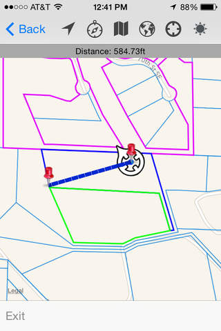
• Measure the distance between two or more points.
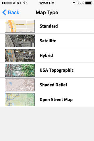
• Control unit display (i.e. meter, feet, etc.).
• Weather forecast at your location.
• Import, export, backup, and share shapefiles using Wolf-Connect Pro.
• Take pictures and associate them to customers and parcels with Tract-Photo.
• Search and Manage customer information and land details.
• Use Tract Navigation (bearing and distance) to help find the property corner locations.
• Use Patented Tract-Lock Technology to alert visually and audibly if you stray outside parcel boundaries.
• Tract-Statistics gives you information about the parcel you have selected: Number of vertices, perimeter, and area.
To learn more, please visit us at http://wolfgis.com.
If you are looking for raw geospatial data including shapefiles, please visit http://myshapefiles.com
If you have any ideas for future updates email us at [email protected].